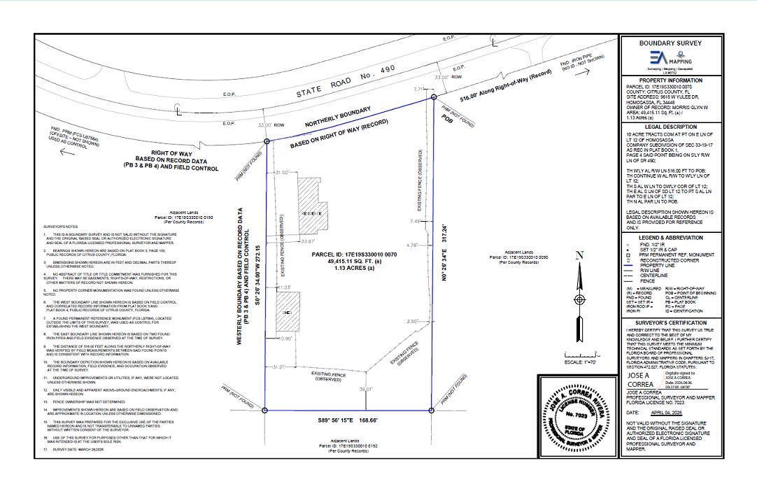
Service

Boundary Survey

Legal property boundaries established by a licensed Florida surveyor and certified per Chapter 472 of the Florida Statutes. Whether you're closing on a property, resolving a neighbor dispute, or preparing for construction, an accurate boundary survey is the legal record that protects your investment.

Boundary Survey

What Is a Boundary Survey?

A boundary survey locates and defines the legal limits of a parcel of land based on the recorded deed, plat, and legal description. Our licensed surveyors research the title history, locate existing monuments, and establish or re-establish corner positions in the field using precision GNSS and total station equipment.

The result is a certified boundary plat that can be recorded, used in legal proceedings, submitted to permitting agencies, and relied upon by title companies and lenders. EA Mapping boundary surveys are signed and sealed by a Professional Land Surveyor licensed in Florida.

What You Receive

  • Signed and sealed boundary plat drawing (PDF and DWG)
  • Corner monument set or found — rebar, caps, or concrete monuments
  • Legal description of the parcel (metes and bounds or lot/block)
  • CAD file (DWG/DXF) compatible with Civil 3D and AutoCAD
  • Field notes and deed research documentation
  • Certificate of survey per Florida Statutes §472.027

Common Use Cases

  • Property sale or purchase closing — required by most lenders
  • Pre-construction permitting and setback verification
  • Fence, wall, or improvement location compliance
  • Boundary line dispute resolution and legal proceedings
  • Subdivision and lot split preparation
  • Easement location and encroachment identification

Ready to get started?

Tell us about your project and we'll respond within 24 hours.

Request a Quote